地形介绍

地域范围:具有一定的界限;地域内部表现出明显的相似性和连续性,地域之间则具有明显的差异性;地域具有一定的优势、特色和功能;地域之间是相互联系的,一个地域的变化会影响到周边地区。
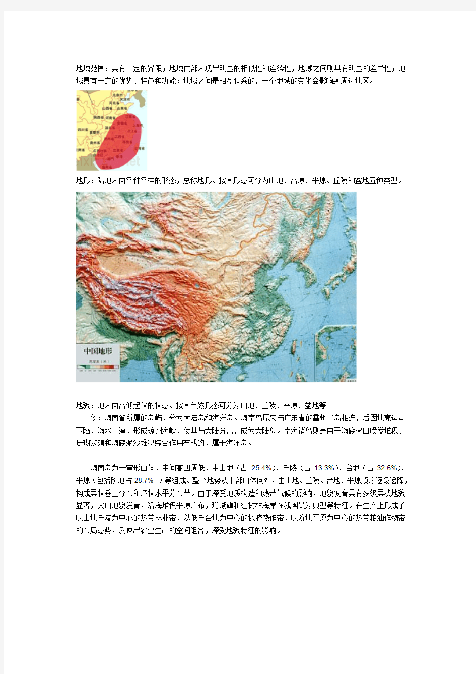
地形:陆地表面各种各样的形态,总称地形。按其形态可分为山地、高原、平原、丘陵和盆地五种类型。
地貌:地表面高低起伏的状态。按其自然形态可分为山地、丘陵、平原、盆地等
例:海南省所属的岛屿,分为大陆岛和海洋岛。海南岛原来与广东省的雷州半岛相连,后因地壳运动下陷,海水上淹,形成琼州海峡,使其与大陆分离,成为大陆岛。南海诸岛则是由于海底火山喷发堆积、珊瑚繁殖和海底泥沙堆积综合作用布成的,属于海洋岛。
海南岛为一穹形山体,中间高四周低,由山地(占25.4%)、丘陵(占13.3%)、台地(占32.6%)、平原(包括阶地占28.7% )等组成。整个地势从中部山体向外,由山地、丘陵、台地、平原顺序逐级递降,构成层状垂直分布和环状水平分布带。由于深受地质构造和热带气候的影响,地貌发育具有多级层状地貌显著,火山地貌发育,沿海堆积平原广布,珊瑚礁和红树林海岸在我国最为典型等特征。在生产上形成了以山地丘陵为中心的热带林业带,以低丘台地为中心的橡胶热作带,以阶地平原为中心的热带粮油作物带的布局态势,反映出农业生产的空间组合,深受地貌特征的影响。
气候环境:是长时间内气象要素和天气现象的平均或统计状态,时间尺度为月、季、年、数年到数百年以上。气候以冷、暖、干、湿这些特征来衡量,通常由某一时期的平均值和离差值表征。
例:热带雨林气候
例:地中海气候
例:高原气候
物产资源:
地下、地表资源丰富,组合条件较好,利用价值高,开发潜力大的自然资源。
包括植物资源、矿产资源、水资源
风土:山川风俗、气候等的总称;
人情:人的性情、习惯。指一个地方特有的地理环境和民间风习等的总称
英文自我介绍合集(大黄蜂资料大集合)
General Introduction I am a third year master major in automation at Shanghai Jiao Tong University, P. R. China. With tremendous interest in Industrial Engineering, I am writing to apply for acceptance into your Ph.D. graduate program. Education background In 1995, I entered the Nanjing University of Science & Technology (NUST) -- widely considered one of the China?s best engineering schools. During the following undergraduate study, my academic records kept distinguished among the whole department. I was granted First Class Prize every semester,In 1999, I got the privilege to enter the graduate program waived of the admission test. At the period of my graduate study, my overall GPA(3.77/4.0) ranked top 5% in the department. In the second semester, I became teacher assistant that is given to talented and matured students only. This year, I won the Acer Scholarship as the one and only candidate in my department, which is the ultimate accolade for distinguished students endowed by my university. Presently, I am preparing my graduation thesis and trying for the honor of Excellent Graduation Thesis. Research experience and academic activity When a sophomore, I joined the Association of AI Enthusiast and began to narrow down my interest for my future research. With the tool of OpenGL and Matlab, I designed a simulation program for transportation scheduling system. It is now widely used by different research groups in NUST. I assumed and fulfilled a sewage analysis & dispose project for Nanjing sewage treatment plant. This was my first practice to convert a laboratory idea to a commercial product.
名家资料英文介绍:奥斯卡·王尔德 Oscar Wilde
Oscar Wilde (1854-1900), Irish poet and dramatist whose reputation rests on his comic masterpieces Lady Windermere's Fan温夫人的扇子(1892) and The Importance of Being Earnest认真的重要性(1895). Among Wilde's other best-known works are his only novel The Picture of Dorian Gray多利安?格雷的画像(1891) and his fairy tales especially "The Happy Prince." Wilde was born on October 16, 1854 in Dublin to unconventional parents - his mother Lady Jane Francesca Wilde (1820-96), was a poet and journalist. His father was Sir William Wilde, an Irish antiquarian古物研究者,收集古物者(antiques), gifted writer, and specialist in diseases of the eye and ear. Wilde studied at Portora Royal School, Enniskillen, County Fermanagh (1864-71), Trinity College, Dublin (1871-74) and Magdalen College, Oxford (1874-78). In 1878 Wilde received his B.A. and in the same year he moved to London. His lifestyle and humorous wit soon made him the spokesman for
世界的地形知识点
第二章第三节世界的地理知识点 姓名:班级: 1、地表各种高低起伏的形态,总称为地形。陆地地形分为平原、高原、 山地、丘陵和盆地五种基本类型。 2、地面某一个地点高出海平面的垂直距离叫做海拔。地面某一个地点高出另一个地点的垂直距离,即两个地点之间的高度差,叫相对高度。 3、陆地五种基本地形的特点 地形类型主要特征 海拔高低地势起伏 平原较低,一般在 200 米以下平坦广阔 高原较高,一般在500米以上起伏不大,边缘比较陡峭 山地较高,多在500米以上坡度较陡,沟谷较深 丘陵较低,大致在500米以下想对高度一般不超过200 米 盆地周围高,中间低。 4.陆地上高峻的山脉主要分布在两大地带。一是太平洋沿岸山脉带,如太平洋东岸自北向南纵贯南、北美洲西部的科迪勒拉山系,主要是有北美洲的落基山脉山脉和南美洲的安第斯山脉组成。二是横贯亚欧大陆南部和非洲洲西北部的山脉带,大体呈东西方向延伸,主要有喜马拉雅山脉、阿尔卑斯山脉和阿特拉斯山脉等。 5、世界上最大的盆地是刚果盆地,世界上最高的高原是青藏高原,世界上最大的平原是亚马孙平原。 6、海底地形:(1)大陆架:陆地向海洋的自然延伸部分,水深一般在 200米以内。 (2)海沟:海洋底部最深的地方。 (3)大洋中脊:大洋中心海底诞生的地方,火山活动比较强烈。 (4)大陆坡:大陆架向外倾斜的陡坡。 7、等高线是指海拔相等的各点连接成的线。 8、在不同的等高线之间涂上不同的颜色,绘制成的彩色的地图,叫分层设色图图。
1、下图所示与名称搭配正确的是() 2、关于等高线地形图的叙述,正确的是() A、等高线上注记的高度是海拔高度 B、等高线上注记的高度是相对高度 C、等高线密集表示坡度较平缓 D、等高线稀疏表示坡度较陡峻 3、关于等高线的叙述,正确的是() A、不在同一等高线上的两点,海拔肯定不同 B、同一条等高线上的两点,海拔肯定相同 C、等高线闭合的地方,表示的是山峰 D、等高线向低处凸出的地方,表示的是山谷 4、相邻两个山顶之间的部位是() A、洼地 B、谷地 C、鞍部 D、脊部 5、读下图完成问题: (1)三个村所在位置的地形名称是: 王村地处;余村地处;李村地处。 (2)以张村为基点,丁山的相对高度约是米。 (3)图中河流甲的流向是。 甲
AT89C51英文介绍资料
AT89C51 Description The AT89C51 is a low-power, high-performance CMOS 8-bit microcomputer with 4K bytes of Flash Programmable and Erasable Read Only Memory (PEROM). The device is manufactured using Atmel’s high density nonvolatile memory technology and is compatible with the industry standard MCS-51? instruction-set and pinout. The on-chip Flash allows the program memory to be reprogrammed in-system or by a conventional nonvolatile memory programmer. By combining a versatile 8-bit CPU with Flash on a monolithic chip, the Atmel AT89C51 is a powerful microcomputer which provides a highly flexible and cost effective solution to many embedded control applications. Features ?Compatible with MCS-51? Products ?4K Bytes of In-System Reprogrammable Flash Memory –Endurance: 1,000 Write/Erase Cycles ?Fully Static Operation: 0 Hz to 24 MHz ?Three-Level Program Memory Lock ?128 x 8-Bit Internal RAM ?32 Programmable I/O Lines ?Two 16-Bit Timer/Counters ?Six Interrupt Sources ?Programmable Serial Channel ?Low Power Idle and Power Down Modes The A T89C51 provides the following standard features: 4K bytes of Flash,128 bytes of RAM, 32 I/O lines, two 16-bit timer/counters, a five vector two-level interrupt architecture, a full duplex serial port, on-chip oscillator and clock circuitry. In addition, the AT89C51 is designed with static logic for operation down to zero frequency and supports two software selectable power saving modes. The Idle Mode stops the CPU while allowing the RAM, timer/counters, serial port and interrupt system to continue functioning. The Power-down Mode saves the RAM contents but freezes the oscillator disabling all other chip functions until the next hardware reset.
英语自我介绍资料
英语自我介绍资料 内容重点;1 开头礼貌用语 2 个人情况(中英文名字,年龄,班级和所在学校) 3 家庭情况(成员,工作情况) 4 个人兴趣(例如绘画,书法,唱歌,跳舞等) 5 结束用语 1 Ladies and gentlemen,good afternoon! Hello everybody/everyone. Nice to meet you 2 I’m very glad to stand here./It’s my pleasure to stand here. First, I will introduce myself. My name is 中文姓名and English name is 英文姓名.I’m 自己年龄years old . I’m in Class 班级Grade 年级。所在学校名称. primary/middle school . 3 There are 几个家庭成员people in my family . My parents / my father, mother and 、 I.(sister,brother) My father is 工作名称.My mother is 工作名称 . 4 I like 自己的兴趣爱好. My favourite food /colour/music/book is 自己喜爱的食物,颜色,音乐,书籍等. 5 I love my family members very much .That ‘s my introduction. Thank you very much ! 英语自我介绍资料 内容重点;1 开头礼貌用语 2 个人情况(中英文名字,年龄,班级和所在学校) 3 家庭情况(成员,工作情况) 4 个人兴趣(例如绘画,书法,唱歌,跳舞等) 5 结束用语 1 Ladies and gentlemen,good afternoon! Hello everybody/everyone. Nice to meet you! 2 I’m very glad to stand here./It’s my pleasure to stand here. First, I will introduce myself. My name is 中文姓名and English name is 英文姓名.I’m 自己年龄years old . I’m in Class 班级Grade 年级。所在学校名称. primary/middle school . 3 There are 几个家庭成员people in my family . My parents / my father, mother and 、 I.(sister,brother) My father is 工作名称.My mother is 工作名称 . 4 I like 自己的兴趣爱好. My favourite food /colour/music/book is 自己喜爱的食物,颜色,音乐,书籍等. 5 I love my family members very much .That ‘s my introduction. Thank you very much
第三节 世界的地形(1)
柳山镇中小学集体备课卡科目地理课时8 年级七 课题第三节世界的地形(1) 教学目标1、理解地形、海拔、相对高度等基本概念,能在相关图中识别。 2、了解五种基本地形的形态特征,运用海拔和相对高度比较平原与高原、山地与丘陵的特点。 3、说出世界陆地两大著名高山带的分布规律,能对照地图说出最著名的山脉、高原、平原和盆地名称以及它们所在的大洲。 4、了解海底地形特征,在海底地形示意图上说出各地形类型的名称。 重点难点1、海拔与相对高度的概念。 2、五种陆地地形的基本特点 教学 方法 与手 段 直观教学法观察法自主学习 教学设计 课内探究 备课区修改区 一、引入新课: 多媒体展示引出地形概念和世界的地形 二、学习新课: 1、学生自学课本27页掌握下列问题。 (1)称为地形。 (2)地形的五种基本类型:___ _、__ __、 ___ ___、___ _、_______。 (3)海拔和相对高度:海拔:指地面某一个地 点高出_____的______距离。相对高度:指地面 某一个地点高出另一个地点的______距离。 2、学生自学后回答,教师做简单总结。 3、多媒体展示示意图读出甲、乙、丙三点 的海拔,计算甲乙两点、乙丙两点的相对高度。 4、过渡,多媒体展示五种陆地地形。 审查组组长签字备课教师签名:辛卫国使用教师 课 内 探 究 5、学生自学课本27--28页掌握下列问题。 (1)完成下表 地形类型 主要特征 共同点 海拔高度地面起伏 平原 高原 山地 丘陵 盆地 (2)山脉分布的两大地带: 环太平洋沿岸山脉带:A、太平洋东岸的_______ 山系:主要由北美洲的_____山脉和南美洲的_____山脉 组成。B、太平洋西岸山脉带。 横贯亚欧大陆南部和非洲西北部的山脉带:由 _________山脉、________山脉和________山脉组成。 (3)说出几个陆地地形的世界之最。 6、学生自学后回答,教师做简单总结。 地形类型 主要特征 共同点 海拔高度地面起伏 平原低(200米以下)平坦广阔 地面起伏小 高原较高 起伏不大 边缘陡峭 山地 较高(500米以 上) 坡度较陡 沟谷较深 地面崎岖不 平 丘陵较低 坡度和缓 相对高度 不超过 200米 盆地四周高,中间低
商业资料英文自我介绍合集篇
A thesis submitted to in partial fulfillment of the requirement for the degree of Master of Engineering 自我介绍合集篇 英语自我介绍范文 General Introduction I am a third year master major in automation at Shanghai Jiao Tong University, P. R. China. With tremendous interest in Industrial Engineering, I am writing to apply for acceptance into your Ph.D. graduate program. Education background In 1995, I entered the Nanjing University of Science & Technology (NUST) -- widely considered one of the China’s best engineering schools. During the following undergraduate study, my academic records kept distinguished among the whole department. I was granted First Class Prize every semester,In 1999, I got the privilege to enter the graduate program waived of the admission test. At the period of my graduate study, my overall GPA(3.77/4.0) ranked top 5% in the department. In the second semester, I became teacher assistant that is given to talented and matured students only. This year, I won the Acer Scholarship as the one and only candidate in my department, which is the ultimate accolade for distinguished students endowed by my university. Presently, I am preparing my graduation thesis and trying for the honor of Excellent Graduation Thesis.
《世界的地形》教学设计
湘教版七年级《地理》(上册) 第二章地球的面貌第三节世界的地形 第一课时教学设计 一、学情学法 七年级的学生虽在小学有零碎接触一些地理知识,但未能形成系统的知识体系和能力,特别是缺乏基本的读图、析图能力,以及对地理事物的理解、想像、分析等地理思维能力和解决地理问题的能力。“地图是地理的第二语言”,教师在教学中要有意识地引导学生观察各种图像,包括示意图、地图、景观图等。通过认真判读、分析、获取地理信息,并应用地理图表说明地理问题。因此在教学中要注重引导学生采用以下三大学法,逐步掌握世界地形的有关地图和地理知识,落实教学主题。 一)、是自主学习法:通过多媒体课件展示的分层设色世界地形图、各种示意图和景观图来设置问题,1、引导学生能读懂地图,利用地图复习旧知识和理解新知识。2、引导学生层层理解五种地形的特点和两大山脉带的分布。 二)、是比较法:通过景观图的感性比较和列图表比较五种地形的异同,增加对世界地形的掌握; 三)、是讨论探究法:通过同学间的共同讨论以及野外调查,了解你的家乡的地形特点,以及这种地形给生活和生产活动带来哪些影响。 二、设计思想 【依据课标】 为满足“学习对生活有用的地理”和“学习对终身发展有用的地理”的教学新理念,根据课标,1、要培养学生掌握阅读和使用地图和地理图表的基本技能;2、利用图表分析比较五种地形的形态特征。 【关键词】 地形、分层设色、海拔、相对高度、高峻、山脉带 【教材内容简析与教材创新处理】 本课时主要是学习陆地地形和学会看分层设色地形图两大内容。根据“地图是地理的第二语言”这一观点,教师完全可以围绕一张分层设色的世界地形图来展开教与学,培
潍坊的英文介绍资料整合
Weifang (simplified Chinese: 潍坊; pinyin: Wéifāng) is a prefecture-level city in central Shandong province, People's Republic of China. It borders Dongying to the northwest, Zibo to the west, Linyi to the southwest, Rizhao to the south, Qingdao to the east, and looks out to the Laizhou Bay to the north. Weifang is a historical city with well known figures. Emperor Shun of the Three Sovereigns and Five Emperors period, the politician Yan Ying (晏婴) of the Spring and Autumn Period, the Confucian scholar Zheng Xuan of the Estern Han Dynasty and the agriculturist Jia Simiao of the Northern Wei Dynasty were all from Weifang. Kong Rong, Fan Zhongyan, Ouyang Xiu, Su Dongpo, Zheng Banqiao, et al. have worked in Weifang historically. In more recent years, revolutionists, litterateurs and artists, such as Wang Jinmei, Chen Shaomin, Wang Yuanjian, Wang Tongzhao, Zang Kejia are well known in China. Weifang also boasts of historical relics and other tourist sites, such as Shihu Garden (from the Late Ming and early Qing Dynasty), Fangong Pavilion (from the Song Dynasty), fossile sites (including dinosaur fossils, in Shanwang, Linqu), Mount Yi National Forest Park, Mount Qingyun and the Old Dragon Spring. Weifang is the world capital of kites. The woodcut new year’s paintings from Yangjiabu are well known. Administration The prefecture-level city of Weifang administers 12 county-level divisions, including 4 districts, 6 county-level cities and 2 counties. * Weicheng District (潍城区) * Kuiwen District (奎文区) * Fangzi District (坊子区) * Hanting District (寒亭区) * Qingzhou City (青州市) * Zhucheng City (诸城市) * Shouguang City (寿光市) * Anqiu City (安丘市) * Gaomi City (高密市) * Changyi City (昌邑市) * Changle County (昌乐县) * Linqu County (临朐县) Geography Nearby cities include Jinan and Zibo to the west, Yantai to the northeast and Qingdao to the southeast. Economy Weifang is home to the large diesel engine company and factory Weichai. The village of Yangjiabu in Hanting district is famous for folk wood-block print (nianhua) and kite production. Weifang regards itself as the 'International Kite Capital' and holds an international kite festival every year in the spring. Notable people * Zheng Xuan (127-200), Eastern Han Dynasty Confucian scholar * Liu Yong (刘墉; 1719-1805), renowned Qing Dynasty bureaucrat --------------------------------------------------------- Culture of Weifang
上海著名景点英文介绍(附图)教案资料
上海著名景点英文介 绍(附图)
※Shanghai Oriental Pearl Tower The Oriental Pearl Tower is a TV tower in Shanghai, China. The Oriental Pearl Tower is located at the tip of Lujiazui in the Pudong district, by the side of Huangpu River, opposite of The Bund. It was designed by the Shanghai Modern Architectural Design Co. Ltd. Principal designers are Jiang Huan Chen, Lin Benlin and Zhang Xiulin. Construction began in 1990 and the tower was completed in 1994. At 468 m (1,535 feet) high, it was the tallest structure in China (excluding Taiwan; see Taipei 101) from 1994–2007, when it was surpassed by the Shanghai World Financial Center. The spheres in the tower The tower features 11 spheres, big and small. The two largest spheres, along the length of the tower, have diameters of 50 m (164 ft) for the lower and 45 m (148 ft) for the upper. They are linked by three columns, each 9 m (30 ft) in diameter. The highest sphere is 14 m (46 ft) in diameter. The entire building is supported by three enormous columns that start underground. Observation levels The tower has fifteen observatory levels. The highest (known as the Space Module) is at 350 m (1148 ft). The lower levels are at 263 m (863 ft) (Sightseeing Floor) and at 90 m (295 ft) (Space City). There is a revolving restaurant at the 267 m (876 ft) level. The project also contains exhibition facilities, restaurants and a shopping mall. There is also a 20-room hotel called the Space Hotel between the two large spheres. Antenna spire
资料集锦英文自我介绍资料
资料集锦英文自我介绍资料 一、Greetings (打招呼) 1. Good morning everyone.大家早上好。 2.Good afternoon, ladies and gentlemen. 先生们,女士们下午好。 3.Good evening, teachers and fellow students. 老师们,同学们晚上好。 6.I’m very happy to introduce myself to you here. 我很高兴在这儿向大家作自我介绍。 二、Basic information (基本自我介绍) 1.My name is Michelle.我叫Jojo. 2.I am Cindy.我叫Cindy. 3.I am 25.我二十五岁了。 4.I am from Hong Kong.我来自香港。 5.I come from Singapore.我来自新加坡。 三、Family (家庭) 1.My home is the home of peace. 我的家是和平之家。 2.My home is the home of joy and delight.
我的家是欢乐和喜悦之家。 3.This is the home of love; 这是爱之家。 4.Those who come in must learn the lessons of love; 进入这家的人将会受到爱的课程。 5.Thus may they know how to love each other. 从而他们将知道如何去互相友爱。 四、 Family members (家庭成员) 1.I have a big and happy family. 我有一个快乐的大家庭。 2.There are three people in my family. 我们家有三口人。 3.My father works for a bank. 我爸爸在一家银行工作。 4.My mother teaches in a high school. 我妈妈在一所中学教书。 5.My mom loves teaching little kids. 我妈妈特别喜欢教小孩儿。 6.I have an older sister. 我有一个姐姐。 7.I have a twin brother.
世界地形主要分为哪几种
世界地形主要分为哪几种? 共分为:平原、山地、丘陵、高原、盆地五种基本类型。 平原:陆地上海拔高度相对比较小的地区称为平原。平原是陆地上最平坦的地域,海拔一般在200米以下。平原地貌宽广平坦,起伏很小,它以较小的起伏区别于丘陵,以较小的高度来区别于高原。平原的类型较多,按其成因,可分为构造平原、侵蚀平原和堆积平原。堆积平原是在地壳下降运动速度较小的过程中,沉积物补偿性堆积形成的平原,洪积平原、冲积平原、海积平原都属于堆积平原;如长江中下游平原就是冲积平原。侵蚀平原,也叫剥蚀平原,是在地壳长期稳定的条件下,风化物因重力、流水的作用而使地表逐渐被剥蚀,最后形成的石质平原。侵蚀平原一般略有起伏状,如我国江苏徐州一带的平原。构造平原是因地壳抬升或海面下降而形成的平原,如俄罗斯平原。世界平原总面积约占全球陆地总面积的四分之一,平原不但广大,而且土地肥沃,水网密布,交通发达,是经济文化发展较早较快的地方。我国的长江中下游平原就有“鱼米之乡”的美称。另外一些重要矿产资源,如煤、石油等也富集在平原地带。
山地:属地质学范畴,地表形态按高程和起伏特征定义为海拔500米以上,相对高差200米以上。 地球陆地的表面,有许多蜿蜒起伏、巍峨奇特的群山。山由山顶、山坡和山麓三个部分组成,平均高度都在海拔500米以上。它们以较小的峰顶面积区别于高原,又以较大的高度区别于丘陵。这些群山层峦叠嶂,群居一起,形成一个山地大家族。 山地的表面形态奇特多样,有的彼此平行,绵延数千公里;有的相互重叠,犬牙交错,山里套山,山外有山,连绵不断。山地的规模大小也不同,按山的高度分,可分为高山、中山和低山。海拔在3500米以上的称为高山,海拔在1000-3500米的称为中山,海拔低于1000米的称为低山。按山的成因又可分为褶皱山、断层山、褶皱一断层山、火山、侵蚀山等。褶皱山是地壳中的岩层受到水平方向的力的挤压,向上弯曲拱起而形成的。断层山是岩层在受到垂直方向上的力,使岩层发生断裂,然后再被抬升而形成的。喜马拉雅山是典型的褶皱山,江西的庐山是断层山,天山山脉属于褶皱一断层山。
英文介绍人的出生
When we were children, we always asked our parents-“Daddy where am I from?”–“Em, you were sent to our house by a fairy.”-“A fairy?”-“Yes, and I know you must be a naught baby at first glance.”-“Why ?”-“You know the baby who are disobedient will be spanked, and your ass is blue.”—“Mommy where am I from?”-“You were picked from a baby tree, a tree full of baby. We wanted another baby at first but when I touched the branch, you were falling from the tree by accident, so we had to bring you to home.” When we grow up we know that statement is not scientific, and I want to ask you where are we from.-“Oh, it was more than twenty years ago, who remembered.” Just a joke. Today let’s to see where are we from. From fertilized egg to birth, this is our development process. There are about 300 million sperm . However, only a sperm may pass through many obstacles and to fertilize an egg. Look, this is a moment that the sperm trying to enter the egg. When the fertilized formed, there is also a change in it’s genes. You know the “XY” represent male, and “XX” represent female.
厦门英文介绍
美丽厦门之英文介绍大全集(一) 01: 厦门英文介绍About Xiamen 02: 厦门八大景八小景Tour Xamen 03: 鼓浪屿英文介绍1 Gulangyu Island 04: 鼓浪屿英文介绍2 Gulangyu Island 05: 厦门市市鸟白鹭City Bird-Egrets 06: 厦门市市花三角梅英文介绍City Flower-Bougainvillea glabra 07: 厦门南普陀英文介绍Nanputuo Temple 08: 集美旅游景点英文介绍Jimei Tourist Area 09: 同安旅游景点英文介绍Tong’an Tourist Area 01.About Xiamen厦门英文介绍 Xiamen is an island city with a rich and dramatic history, replete with pirates, rebel leaders, and European merchants. Now linked to mainland Fujian by a causeway, Xiamen retains a strong international flavor. Known in the West as Amoy, Xiamen has a long history as a port city, and later became a center of British trade in the 19th century. Their foreign settlements, later taken over by Japanese invaders at the start of World War II, were established on the nearby small Gulangyu Island. Many of the old treaty-port and colonial buildings in Western styles survive. Xiamen was declared one of China’s first Special Economic Zones in the early 1980’s, taking advantage of the city’s heritage as a trading center and the proximity to Taiwan. Today Xiamen is one of China’s most attractive and best-maintained resort cities. Xiamen was founded in 1394 at the beginning of the Ming dynasty as a center of defense against coastal pirates. Its prosperity was due to its deepwater sheltered harbor, that supplanted nearby Quanzhou, the port that had been the center of the maritime trade with the Indies. In the mid-17th century, Xiamen and Gulangyu Island became a stronghold of Zheng Chenggong, known in the West as Koxinga, a Ming loyalist who held out against the Manchu invaders until being driven to Taiwan. Born in Japan to a Chinese pirate father and a Japanese mother, Zheng became allied with holdout Ming princes in the south who
世界地形主要分为哪几种
世界地形主要分为哪几 种 集团标准化工作小组 #Q8QGGQT-GX8G08Q8-GNQGJ8-MHHGN#
世界地形主要分为哪几种 共分为:平原、山地、丘陵、高原、盆地五种基本类型。 平原:陆地上海拔高度相对比较小的地区称为平原。平原是陆地上最平坦的地域,海拔一般在200米以下。平原地貌宽广平坦,起伏很小,它以较小的起伏区别于丘陵,以较小的高度来区别于高原。平原的类型较多,按其成因,可分为构造平原、侵蚀平原和堆积平原。堆积平原是在地壳下降运动速度较小的过程中,沉积物补偿性堆积形成的平原,洪积平原、冲积平原、海积平原都属于堆积平原;如长江中下游平原就是冲积平原。侵蚀平原,也叫剥蚀平原,是在地壳长期稳定的条件下,风化物因重力、流水的作用而使地表逐渐被剥蚀,最后形成的石质平原。侵蚀平原一般略有起伏状,如我国江苏徐州一带的平原。构造平原是因地壳抬升或海面下降而形成的平原,如俄罗斯平原。世界平原总面积约占全球陆地总面积的四分之一,平原不但广大,而且土地肥沃,水网密布,交通发达,是经济文化发展较早较快的地
方。我国的长江中下游平原就有“鱼米之乡”的美称。另外一些重要矿产资源,如煤、石油等也富集在平原地带。 山地:属地质学范畴,地表形态按高程和起伏特征定义为海拔500米以上,相对高差200米以上。 地球陆地的表面,有许多蜿蜒起伏、巍峨奇特的群山。山由山顶、山坡和山麓三个部分组成,平均高度都在海拔500米以上。它们以较小的峰顶面积区别于高原,又以较大的高度区别于丘陵。这些群山层峦叠嶂,群居一起,形成一个山地大家族。 山地的表面形态奇特多样,有的彼此平行,绵延数千公里;有的相互重叠,犬牙交错,山里套山,山外有山,连绵不断。山地的规模大小也不同,按山的高度分,可分为高山、中山和低山。海拔在3500米以上的称为高山,海拔在1000-3500米的称为中山,海拔低于1000米的称为低山。按山的成因又可分为褶皱山、断层山、褶皱一断层山、火山、侵蚀山等。褶皱山是地壳中的岩层受到水平方向的力的挤压,向上弯曲拱起而形成的。断层山是岩层